

Sotamar Diving Center
SSI Instructor Training Center in Cadaqués running guided dives to 25+ Cap de Creus Natural Park sites and a blue shark snorkeling program.
SSI9 services4 languages
Also known as: Cova Tamariu (RNP)
A ~31 m reef point inside one of Cap de Creus's marine Partial Nature Reserves, mapped on the park's own eco-briefing sheet with six illustrated species.
Last updated September 2026
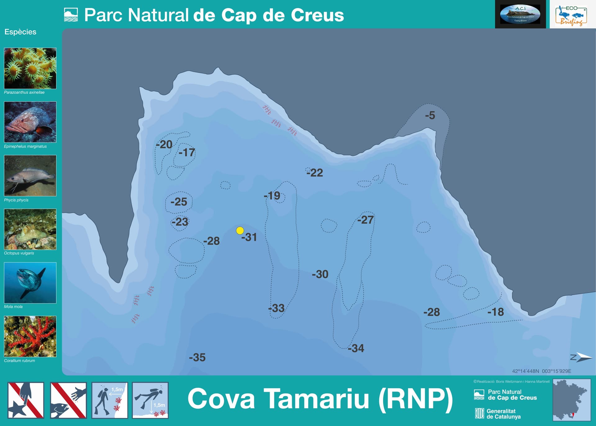
The park's own underwater-itinerary chart drops a single marked point here, right against the printed -31 metre figure, inside a dense contour band that runs from about -25 to -34 metres. Despite the cave in its name (cova is Catalan for cave), the chart shows no overhead passage at this point, only open, contoured seabed. Two of the six species the sheet illustrates for this exact spot get their own location icons on the same chart: a cluster of yellow cluster anemone and a stand of red coral, each pinned to a specific spot in the contour pattern. Dusky grouper and forkbeard work the same depth band, with common octopus denning in the rock nearby.
Cova Tamariu earns its place on the map through the Catalan park authority's own itinerary programme: a dedicated eco-briefing sheet, an exact coordinate and an illustrated species list.1 That sheet tags this specific point inside one of Cap de Creus's three marine Partial Nature Reserves and marks a single surveyed depth of roughly 31 metres, deep enough to call for Deep certification.
The sheet for this exact point carries a no-touch and no-fishing icon plus two 1.5-metre clearance markers, one from the reef wall and one from the seabed, on top of the park's standing rule against touching or removing anything anywhere in the reserve. Independent diving is allowed park-wide with prior notice, capped at six dives a day, thirty a week and 120 a year per boat, not per individual diver. At roughly 31 metres this point works below the area's typical summer thermocline, near 15 metres: budget for cold water close to 14 degC at working depth, not the warmer layer near the surface.
What makes this dive site stand out.
Tagged (RNP), inside one of Cap de Creus's three marine reserves.
The park's own chart pins the dive here, beside the printed -31 m figure.
Dusky grouper, forkbeard and red coral headline the sheet's own species panel.
The sheet's own icons call for staying 1.5 m off the reef and off the seabed.
42.2408°N, 3.2655°E
The marked point sits past the Advanced Open Water 30 m ceiling, calling for Deep certification.
Protecting this site
What this site protects, and what divers do to avoid damaging it.
Book a guided dive at this site.
SSI Instructor Training Center in Cadaqués running guided dives to 25+ Cap de Creus Natural Park sites and a blue shark snorkeling program.
Get in touch to add or claim your dive center listing on DiveCodex.
Dive centres in Catalonia must require insurance from every diver on their dives, and must be able to offer a policy to anyone who has none.
No. This dive point is inside Cap de Creus Natural Park, near Cadaqués. The town of Tamariu, in Palafrugell municipality, is a different place, about 35.8 km to the south.
The point's own sheet tags it (RNP) without naming which of the park's three Partial Nature Reserves (Cap Gros, Cap de Creus, Cap Norfeu) it falls inside.
The park's own sheet gives this point's coordinate and its marked depth but does not say whether it is a boat-moored point or a shore entry. Confirm the approach with whoever plans the dive before you go.
Log your dives - notes, photos, conditions and the marine life you saw - and share them as one public diver profile. What you share helps the next diver, too.
Log every detail
Depth, duration, conditions, gear, buddy, notes — all in one place. Import from Suunto and other dive computers.
Track marine life
Record species sightings on each dive. Build a personal catalogue of everything you've seen underwater.
Your public dive profile
Share your dive history, stats, and experiences with a profile page you control. Show the world where you've been.