Posidonia Dive
SSI Diamond Instructor Training Center at Port Balis marina, 35 km north of Barcelona, running 24 boat dive sites on the Maresme coast year-round.
SSI7 services3 languages
Easy 15-22m Maresme boat dive on twin parallel rocky ridges with a posidonia and sand corridor between them.
Last updated April 2026
The anchorage drops onto the western flank of the easternmost ridge at 15-16m. From there the formation opens into two low parallel ridges running SW-NE on a sandy floor — flatter than most Maresme barras, with a healthy Posidonia oceanica meadow filling the corridor between them and lining the sandy flanks.
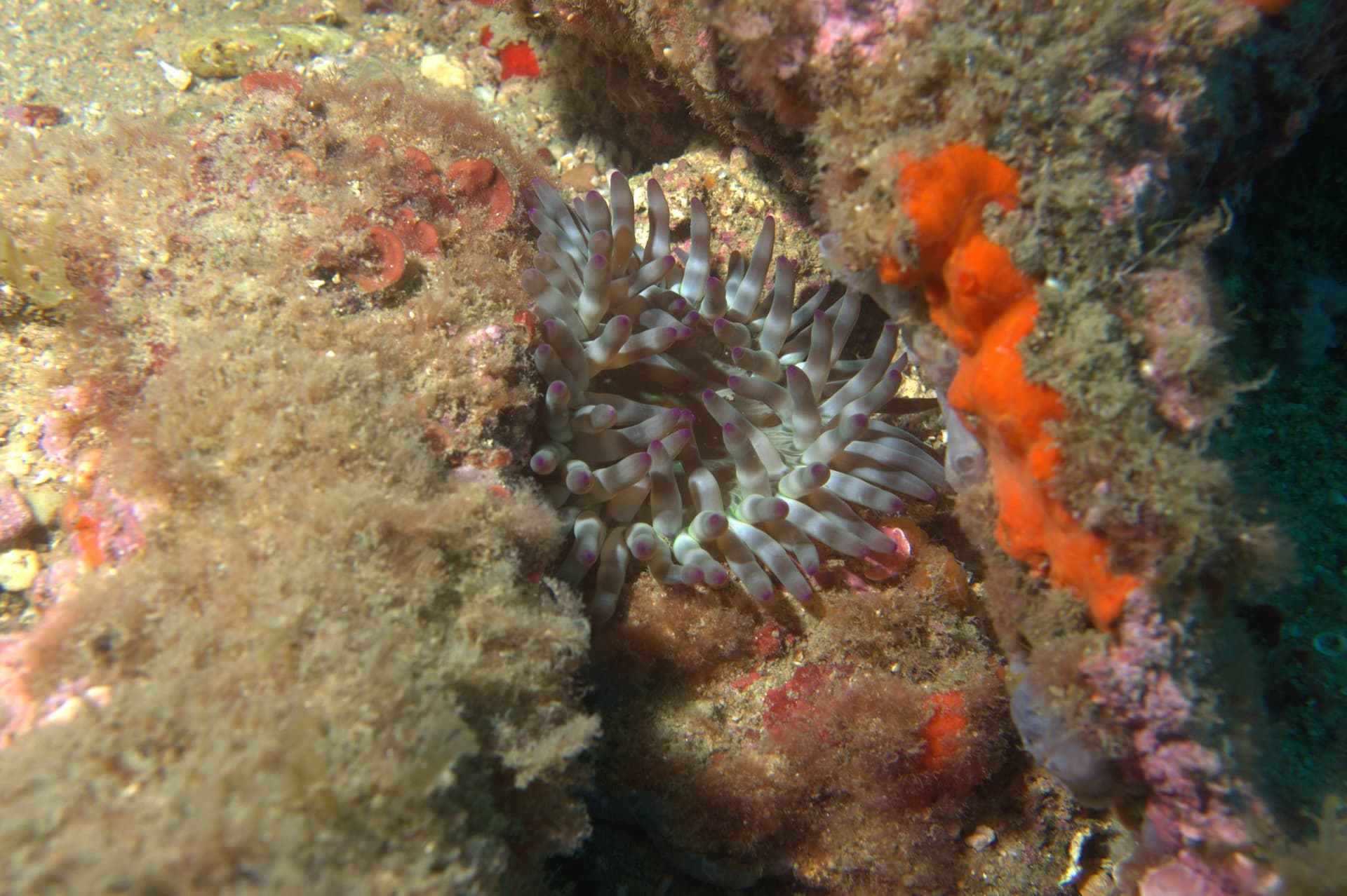
Heading north-east, the bottom slopes gently from 15m to about 22m. The route follows the posidonia-sand interface with the rock on the inshore side, doubling as a navigation reference and the macro ground for the return leg. On a quiet day this is a current-free swim through castanuela schools and Mediterranean wrasses, with red starfish hidden in the leaves and the occasional moray below the rocks. A medium brown wrasse (Labrus merula, merlo) feeding undisturbed in the posidonia is uncommon enough to log.
The two ridges converge on the north-east end. Coming back along the chosen ridge, divers move away from that merge point — and that is where the navigation question lives. With two parallel features rather than one, an inattentive return on the wrong ridge can put divers well off the anchor, particularly when spring or post-rain visibility tightens. The closing minutes belong to the ridge tops, where in cooler months the rock holds pink flatworms, Cratera peregrina, and pairs of vaquita suiza. The seaward side opens onto the blue close enough that fearless schools of barracuda have swept in and circled the divers on the right day.
La Calzada is the easy-profile cousin of the deeper Maresme barres. Within Open Water limits at the anchorage and with a deeper option toward 22m for AOW divers, the dive offers the slow, photographic profile the area is built for: long bottom time, macro on the ridge tops in cooler months, the open blue close enough for the occasional pelagic visitor.
The geology is part of the appeal. The Maresme barras are natural fossilised-sandstone ridges left by Holocene sea-level rise — old beach and coastal-sand deposits cemented into rock and submerged as the post-glacial seas advanced. The cluster's depth banding from roughly 14m to past 30m traces old shoreline tiers, and La Calzada sits in the shallower band. The twin-ridge geometry, with a productive posidonia-sand corridor between, is the structural distinction within the cluster — most neighbouring barras are single ridges.
There is also an off-chart feature, mentioned only on the boat ride back. Somewhere on the formation, a previous local centre intentionally submerged decommissioned scuba tanks as informal octopus refuge. A recent dive passed one tank in transit; the broader cluster is reportedly elsewhere on the site.
Air is comfortable for the 22m typical profile, so Nitrox is more a back-to-back-day choice than a site-specific recommendation. From November through April, drysuit or 7mm semi-dry with hood and gloves matches the bottom band; in summer a 5mm with hood works, with awareness that the 20m+ floor sits below the thermocline and reads several degrees cooler than the surface.
The real demand is navigation. Two parallel ridges converging on the north-east end make the return leg less self-evident than a single-ridge barra; one 2008 dive in 3m visibility ended in buddy separation and an early ascent. Standard kit applies: SMB, dive computer, compass, cutting tool, and a torch for the ridge cracks. Budget gas for the closing minutes on the rock crests, and mention the sunken-tank cluster at the briefing if you want to look for it.
What makes this dive site stand out.
Two low rocky ridges run SW-NE on a sandy bottom, flatter than typical Maresme barras
Anchorage at 15m on the western flank; the NE end slopes gently down toward 22m
Pink flatworms, Cratera peregrina, and vaquita suiza pairs concentrate on the rock crests
A healthy meadow fills the gap between the ridges and lines the sandy flanks
41.5446°N, 2.5213°E
Book a guided dive at this site.
SSI Diamond Instructor Training Center at Port Balis marina, 35 km north of Barcelona, running 24 boat dive sites on the Maresme coast year-round.
Get in touch to add or claim your dive center listing on DiveCodex.
Depth and gas are easy; navigation is the real demand. Two parallel ridges that converge on the NE end mean an inattentive return on the wrong ridge can end well off the anchor, particularly in lower visibility.
Log your dives - notes, photos, conditions and the marine life you saw - and share them as one public diver profile. What you share helps the next diver, too.
Log every detail
Depth, duration, conditions, gear, buddy, notes — all in one place. Import from Suunto and other dive computers.
Track marine life
Record species sightings on each dive. Build a personal catalogue of everything you've seen underwater.
Your public dive profile
Share your dive history, stats, and experiences with a profile page you control. Show the world where you've been.