Poseidon Calella
PADI 5 Star IDC dive centre in Calella de Palafrugell, Costa Brava, operating since 1969 with beach-launch boat access to Ullastres and the Boreas wreck.
PADI / SSI6 services5 languages
A coffee bean-shaped rock at the mouth of Tamariu port, 9-24m, sheltered from the tramuntana and packed with conger and moray eels.
Last updated May 2026
Drop onto the sand at the foot of the rock and pick a direction. The coffee bean shape gives you a single feature to circle, with the crown at around 12m and the perimeter sand edge running down to 24m. Torch on. The interest is in the cracks: morays at the entrance, conger eels deeper in, octopus tucked into the side recesses. Triton's own briefing puts it plainly. Check the cracks carefully, and the dive plan is exactly that.
A guide can hold OW students on the shoulders at 9-12m while AOW divers slip down to the deeper sand interface. Forty to fifty minutes pass without effort at this profile, and the navigation question never really comes up. You came in on the rock, you leave from the rock, and what was in between is whatever you found in the gaps.
Montiell earns its place on the schedule when the wind closes everything else. Tamariu sits low under a north headland, and when the tramuntana shuts down Cap de Begur and Furió Fitó, the local centres redirect here and the boat goes out anyway. Triton describes it as sheltered to the north, recommended above all when the tramontana blows hard.
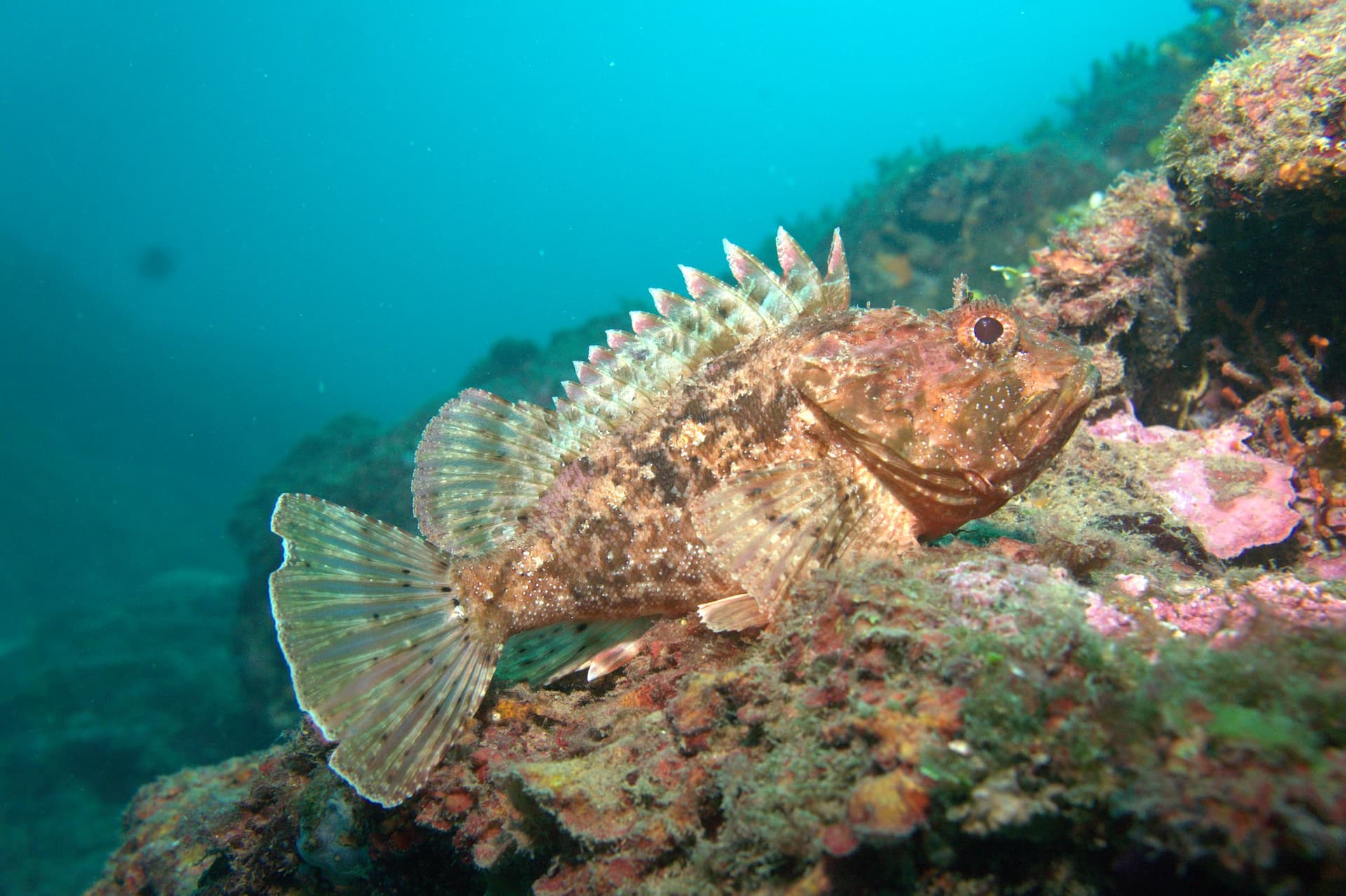
The other thing the rock has, more than its neighbours, is eel density. The English name "Conger Reef" tracks user-logged sightings rather than marketing copy, and morays peak heavily through July and August. The dive is methodical, not dramatic. No walls dropping into blue water, no swim-throughs to thread, no pelagic moments. Slow inspection of one rock, with a torch.
Bring a torch. Without one the cracks are dark and the resident species stay invisible. The mixed-level profile is genuine: OW students on the rock crown, AOW divers on the deeper sand edge, same boat, same dive plan. If you are pushing the 24m max, the surface-to-bottom temperature drop in summer is real, and a 5mm full suit with hood beats a shorty.
The site is sheltered, but the sheltered framing is north-wind specific. In southerly weather it loses its protection. Check the morning forecast with Stollis or Triton before committing the day to it. Pricing is by boat departure rather than per site, so rates apply at the centre's standard guided-dive level.
What makes this dive site stand out.
Sheltered north of Tamariu port, the local plan B when wind closes the headlands
Crevices across the rock hold the highest eel sightings of any Tamariu site
Coffee bean shape is its own orientation aid; circle the formation and surface
9-24m profile lets OW students and AOW divers share the same boat
41.9163°N, 3.2147°E
Book a guided dive at this site.
PADI 5 Star IDC dive centre in Calella de Palafrugell, Costa Brava, operating since 1969 with beach-launch boat access to Ullastres and the Boreas wreck.
Family-run SSI and PADI center in Tamariu since 1971, with a seahorse-rich house reef, 13 dive sites by boat, and children's programs from age 8.
Family-owned dive center in Llafranc since 1979, with 4.9/5 on 717 Google reviews, covering 11 sites across two Costa Brava dive areas.
Get in touch to add or claim your dive center listing on DiveCodex.
Compact circuit around a single rock, sheltered conditions, clear sand-rock interface for orientation.
Log your dives - notes, photos, conditions and the marine life you saw - and share them as one public diver profile. What you share helps the next diver, too.
Log every detail
Depth, duration, conditions, gear, buddy, notes — all in one place. Import from Suunto and other dive computers.
Track marine life
Record species sightings on each dive. Build a personal catalogue of everything you've seen underwater.
Your public dive profile
Share your dive history, stats, and experiences with a profile page you control. Show the world where you've been.