
CIPS Dive
PADI/CMAS/FFESSM centre in El Port de la Selva, running since 1994; daily boat dives across ~20 Cap de Creus sites including Massa d'Or, April-October.
PADI / CMAS / FFESSM3 services4 languages
Also known as: Illa de la Figuerola, La Ferrera, Racó de la Figuerola
Boat-only wall and sandy-bottom dive on Cap de Creus's Mar d'Amunt shore, 5-30m, with a rare sharptail snake eel and ray-rich sand at the base.
Last updated September 2026
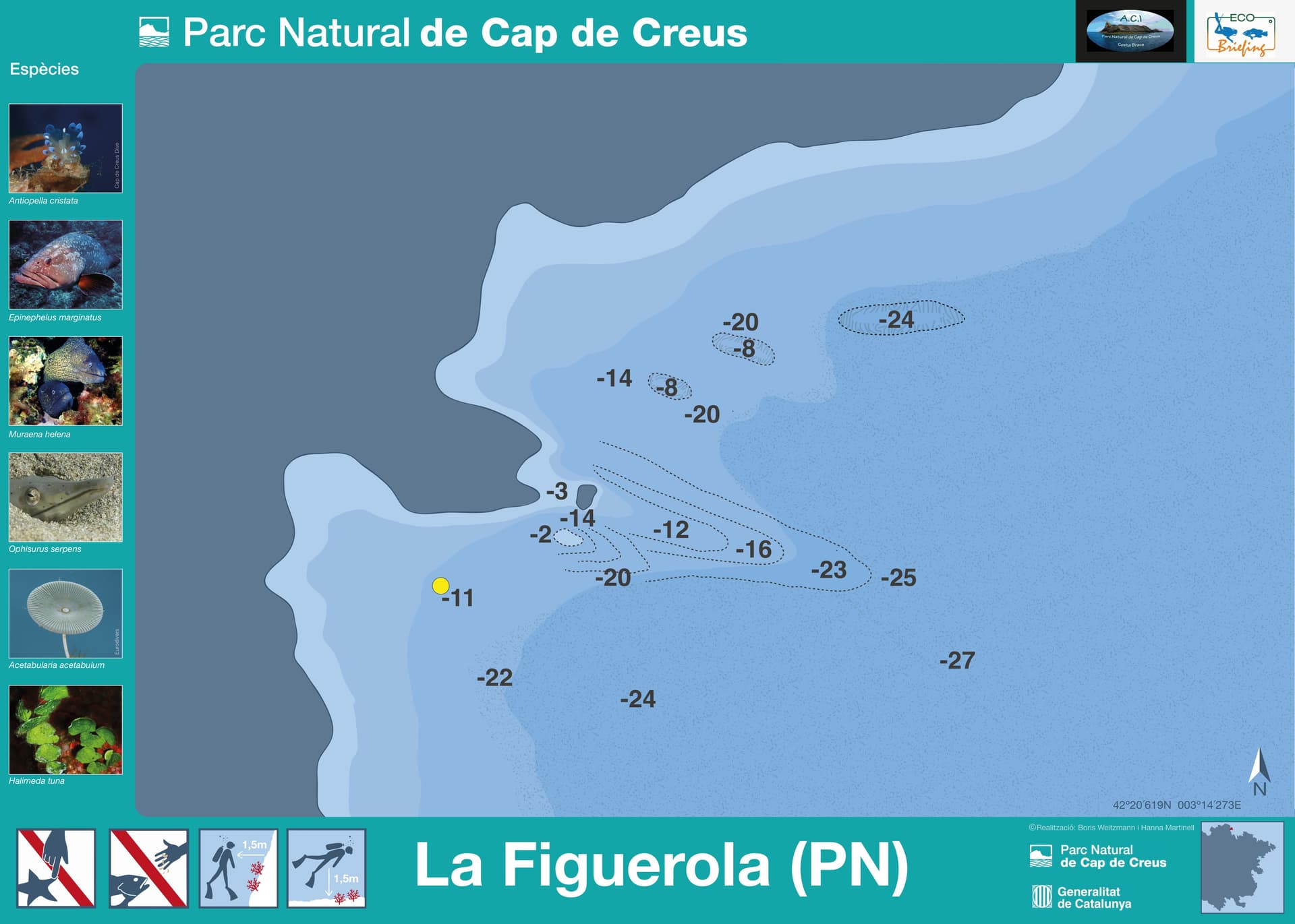
A rocky wall runs down from a park mooring buoy off the islet the 2025 Cap de Creus park map labels "Illa de la Figuerola", on the Mar d'Amunt shore between Cap Gros and Illa de la Galera. The wall holds through its upper and middle stretch before flattening into sand at the base, where the site's sandy-bottom fauna concentrates. Three named centres run eco-guided routes here: Centre d'Immersió Cap de Creus from Llançà, and one each based in Port de la Selva and in Colera itself. Access is by boat only, tied to one of the park's mooring buoys.
The sand at the base of the wall is this site's own signature: two independent operators have recorded a sharptail snake eel here, one of them naming it as the only spot where they have sighted it in the rock-sand transition. Rays work the same sandy ground, torpedo rays among them, and weeverfish bury into the sediment nearby, at the same depth.
A 5mm wetsuit covers the shallow band, but the fuller working depth crosses the local thermocline to a bottom near 14°C past 20 metres, where a 7mm suit or a hooded semi-dry is the more realistic choice. The sandy base under the wall is easy to mistake for empty ground: it carries a venomous species buried out of sight, so keep clear of the bottom without settling on it.
What makes this dive site stand out.
Rays, weeverfish and a rare sharptail snake eel work the sand at the base of the wall
A rocky wall runs from mid-depth down to a sandy bottom past 20 metres
Guided routes run from three different ports: Llançà, Port de la Selva and Colera
One dive catalog describes it as a refuge from the area's dominant wind, which can close more exposed points along this coast
42.3436°N, 3.2379°E
No best-season statement specific to La Figuerola is confirmed; area-wide, April/May and September/October are noted for the clearest visibility in Cap de Creus Natural Park.
Confirm current pricing with your chosen centre in Llançà, Port de la Selva or Colera.
The shallow 5-18m band one operator describes sits within Open Water limits; the deeper part of the contested range, to 28-30m, calls for Advanced Open Water.
Summary
Rated for all levels by the regional eco-guide association and described as beginner-friendly by a dive catalogue; that reading holds for the shallow band, while the deeper end of the contested range needs Advanced Open Water.
Safety considerations
What can go wrong here, and what divers do about it. Conditions change - take the briefing from the operator on the day.
Book a guided dive at this site.
PADI/CMAS/FFESSM centre in El Port de la Selva, running since 1994; daily boat dives across ~20 Cap de Creus sites including Massa d'Or, April-October.
Small PADI centre in Camping Sant Miquel, working Colera's Tramontana-sheltered coast into France's Cerbère-Banyuls reserve.
Get in touch to add or claim your dive center listing on DiveCodex.
Dive centres in Catalonia must require insurance from every diver on their dives, and must be able to offer a policy to anyone who has none.
The regional eco-guide association's route registry, a dive-site catalogue's photo credit and the 2025 official Cap de Creus park map all name this exact point 'Figuerola'; the park map labels it 'Illa de la Figuerola' on its buoy chart. One operator's own dive-site list instead calls the same pin 'La Ferrera', with no further description on that page. Search and book the site as 'Figuerola' or 'La Figuerola', the name the park's own map and the regional association use.
No, despite sharing the word 'Ferrera'. A dive-site catalogue places 'El Bau de la Ferrera' near Roses and Cadaqués, at coordinates on the park's southern side, run by its own operator there. La Figuerola sits on the Mar d'Amunt shore instead, off the islet the official park map labels 'Illa de la Figuerola', near Port de la Selva, Llançà and Colera: a different pin, a different sector, a different centre behind each name.
Log your dives - notes, photos, conditions and the marine life you saw - and share them as one public diver profile. What you share helps the next diver, too.
Log every detail
Depth, duration, conditions, gear, buddy, notes — all in one place. Import from Suunto and other dive computers.
Track marine life
Record species sightings on each dive. Build a personal catalogue of everything you've seen underwater.
Your public dive profile
Share your dive history, stats, and experiences with a profile page you control. Show the world where you've been.