
Cap de Creus Dive
PADI 5-Star center in El Port de la Selva with brand-new Aqualung gear, max 4 divers per guide, and year-round boat diving in Cap de Creus Natural Park.
PADI / SSI10 services4 languages
Also known as: Illa de la Galera, Illa Galera, Isla Galera
Boat-only rock islet on Cap de Creus's north shore, working 18-45 m between Figuerola and Taballera, with gorgonians, red coral and barracuda.
Last updated September 2026
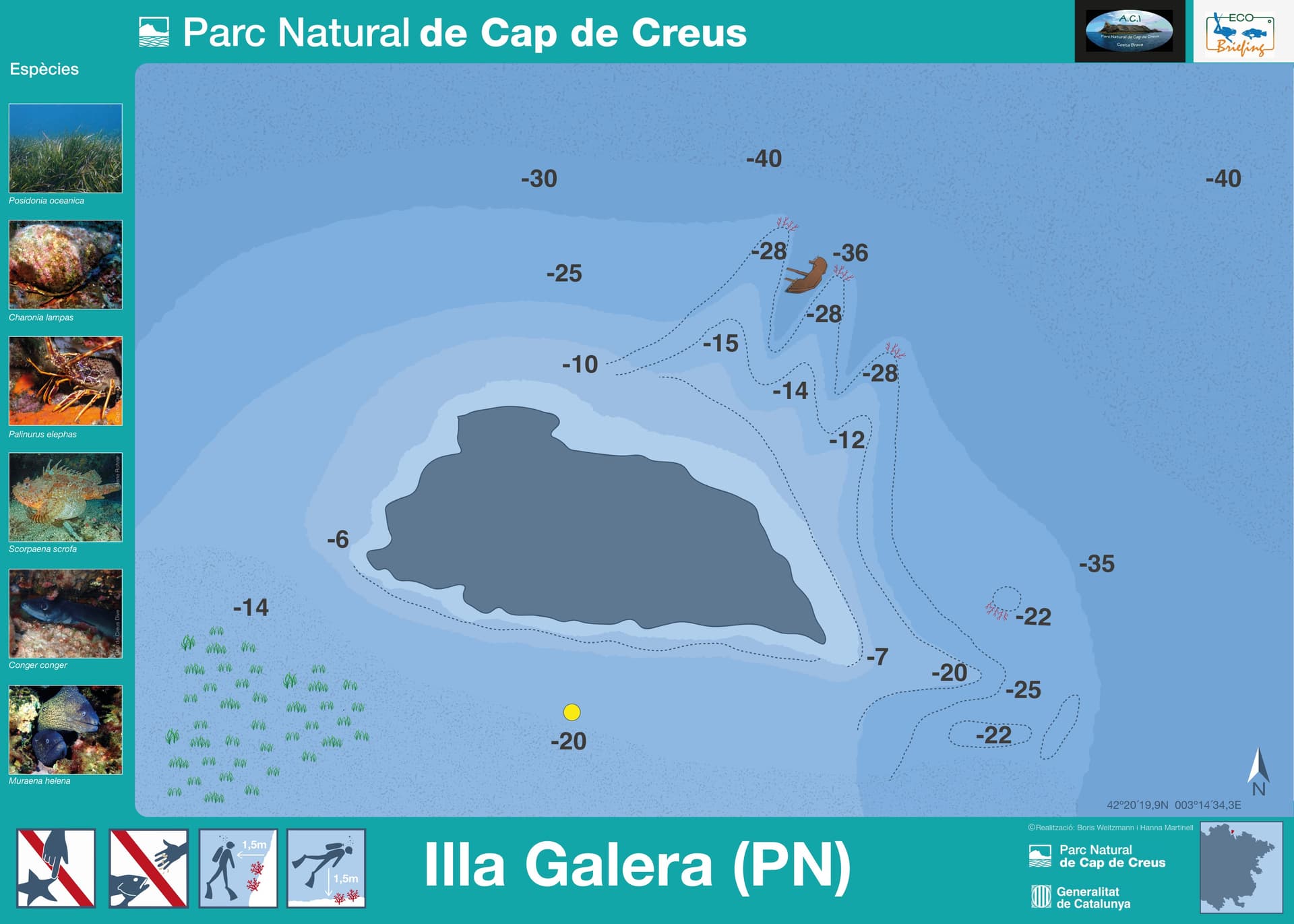
A rock islet breaks the surface off Cap de Creus's Mar d'Amunt shore, positioned between Illa de la Figuerola to the west and Cala Taballera to the east on the park's own dive map. Boats tie off to one of the park's mooring buoys and drop straight onto the rock, which falls away as a single continuous wall rather than a slope. Diving Center Colera's own route works the full wall between 18 and 45 metres; a separately published catalogue listing gives a wider 5 to 40 metre span for the same site, and no operator offers a shallower option here. The rock carries gorgonians and red coral through its depth, with barracuda working the open faces and nudibranchs on the same formations.
Gorgonians and red coral do not thin out as the wall goes deeper: they hold the rock from the shallow end of the route to well past 40 metres, with barracuda and nudibranchs holding the same stretch, not favouring one depth band over another. That continuity comes with a trade-off. Every published number for this dive, whichever range you go by, already sits past standard Open Water limits, so there is no shallower stretch to retreat to if conditions change partway through; booking this wall means committing to its full depth range, not a lighter version of it.
Published depth figures for La Galera disagree by a wide margin: one operator's own guided route works the wall from 18 to 45 metres, while a catalogue listing for the same point gives 5 to 40 metres. Neither figure puts you in shallow, beginner territory, so agree a personal depth limit with your buddy before you drop, hold at least Advanced Open Water, and have your centre confirm on the day which route you are actually diving; the full wall, past the standard 40 m recreational ceiling, calls for Deep or Technical certification depending on how your centre programmes it. This north-coast point carries the area's Tramuntana wind risk, which can shut exposed points on this shore for days regardless of season. The published coordinates come from a single dive-site catalogue; treat them as approximate. Access is by park-managed mooring buoy only, capped at three hours, with no anchoring allowed inside the buoy field; build a private boat's schedule around that window.
What makes this dive site stand out.
Vertical relief across a published depth of roughly 18 to 45 metres
Cover the rock through its depth, alongside barracuda and nudibranchs
Reached only by boat, tied to a park-managed mooring buoy
Sits on the official park map between Illa de la Figuerola and Cala Taballera
42.3395°N, 3.2426°E
The practical season across the wider Cap de Creus park applies at this point.
The shallow end of the published range (18 m) already sits at the edge of recreational Open Water limits, and the fuller route, published to 45 m, sits past the standard recreational ceiling of 40 m and calls for Deep or Technical certification depending on how a centre programmes it. A catalogue's wider 5-40 m figure does not change this: there is no shallower, beginner-accessible option at this site.
Summary
Reflects the published depth range, all of which sits beyond Open Water limits.
Safety considerations
What can go wrong here, and what divers do about it. Conditions change - take the briefing from the operator on the day.
Book a guided dive at this site.
PADI 5-Star center in El Port de la Selva with brand-new Aqualung gear, max 4 divers per guide, and year-round boat diving in Cap de Creus Natural Park.

PADI/CMAS/FFESSM centre in El Port de la Selva, running since 1994; daily boat dives across ~20 Cap de Creus sites including Massa d'Or, April-October.
Small PADI centre in Camping Sant Miquel, working Colera's Tramontana-sheltered coast into France's Cerbère-Banyuls reserve.
Get in touch to add or claim your dive center listing on DiveCodex.
Dive centres in Catalonia must require insurance from every diver on their dives, and must be able to offer a policy to anyone who has none.
They are two separate places with similar-looking names, not a mismatch on the map. The official 2025 Cap de Creus park map labels this dive point 'Illa de la Galera,' between Illa de la Figuerola and Cala Taballera; several hundred metres further along the same coast, near Punta d'es Tres Frares, the same map labels a different point 'Es Tres Fares de Galladera' and a nearby cove 'Cala Galladera.' Book and search this dive as 'Galera,' not 'Galladera.'
Plan for the deeper figures either way. One operator that runs this dive works the wall between 18 and 45 metres, already past Open Water limits at the shallow end and past the 40 m recreational ceiling at the full route, which calls for Deep or Technical certification depending on how a centre programmes it; a separately published catalogue listing gives a wider 5 to 40 metre span for the same point, but no operator offers a shallower, beginner-accessible section here. Hold at least Advanced Open Water, and check with your guiding centre before committing to the deeper wall.
No, these are unrelated namesakes: a 'Cala Galera' dive site is listed off Isola delle Femmine in Sicily, and 'Buceo La Galera' is a dive centre's name in the Dénia/Xàbia area of the Costa Blanca, hundreds of kilometres south. This La Galera is the islet the official Cap de Creus park map places off Port de la Selva and Colera, on Catalonia's north coast.
Log your dives - notes, photos, conditions and the marine life you saw - and share them as one public diver profile. What you share helps the next diver, too.
Log every detail
Depth, duration, conditions, gear, buddy, notes — all in one place. Import from Suunto and other dive computers.
Track marine life
Record species sightings on each dive. Build a personal catalogue of everything you've seen underwater.
Your public dive profile
Share your dive history, stats, and experiences with a profile page you control. Show the world where you've been.