

Diving Cap de Creus
German-run CMAS/RSTC dive centre on Cadaqués's Es Caials shore since 1975, with two shore dives near the door and boat trips on an informal daily schedule.
CMAS / other4 services2 languages
Also known as: Cala Bona (El Tregastel wreck), Pecio del Tregastel
A small Cap de Creus cove, reached on foot or by boat, built around the wreck of the Tregastel, a French steamer said to have gone down here in 1938.
Last updated September 2026
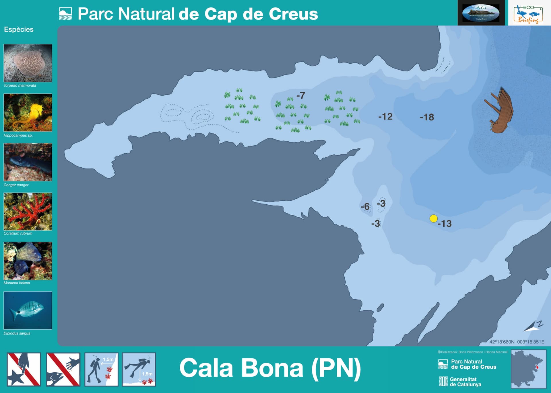
A shallow shelf of rock and Posidonia meadow steps down from Cala Bona's own cove before falling away, on the seaward side, toward the wreck: a French steamer locally called the Tregastel, said to have gone down here in 1938. The hull is worked bow to stern at your own pace, with no fixed briefing route. Morays and conger hold the crevices, lobsters and sea slugs sit along the plating, and a marbled electric ray or a seahorse can turn up on the sand and rock in between.
Cala Bona is a wreck itinerary through and through, built entirely on the remains of the Tregastel, locally known also as the Pecio del Tregastel. The cove offers little beyond the water: no settlement, no restaurant, no accommodation, just the path down from Cala Jugadora and the wreck waiting below it.
An eco-briefing before the dive, and a ban on touching, removing or altering anything, wreck material included, apply throughout the park, as does the 80 cm limit on fin length; diving independently, without a centre, means filing your dive plan with the park authority in advance. The wreck itself invites more than a fly-by, with divers working it from bow to stern and in and around the hull. Treat any enclosed section the way you would treat an overhead environment generally: keep the exit in sight, and never go further in than your training and your gas allow.
What makes this dive site stand out.
A French steamer, locally said to have gone down here in 1938, worked bow to stern
Reached on foot from Cala Jugadora, or by boat
Both recorded for this exact point on the park's own itinerary sheet
Morays, conger, lobsters and sea slugs share the plating and crevices
42.3110°N, 3.3058°E
The shallower of the two published depth readings, 12 to 18 metres, stays within Open Water limits; the deeper reading, 25 to 30 metres, calls for Advanced Open Water.
Summary
The wreck is worked bow to stern, not swum as an open reef, and the deeper of the two published readings reaches Advanced Open Water depth, so treat the whole dive as advanced even at the shallower figure.
Safety considerations
What can go wrong here, and what divers do about it. Conditions change - take the briefing from the operator on the day.
Book a guided dive at this site.
German-run CMAS/RSTC dive centre on Cadaqués's Es Caials shore since 1975, with two shore dives near the door and boat trips on an informal daily schedule.
SSI-listed dive centre inside the Carpe Diem Cadaqués complex, running since 2008 with three daily boat departures across 15 named Cap de Creus sites.

SSI Instructor Training Center in Cadaqués running guided dives to 25+ Cap de Creus Natural Park sites and a blue shark snorkeling program.
Get in touch to add or claim your dive center listing on DiveCodex.
Dive centres in Catalonia must require insurance from every diver on their dives, and must be able to offer a policy to anyone who has none.
No. That Cala Bona is a resort town on Mallorca's east coast, in the municipality of Son Servera, with no connection to diving. This Cala Bona is a small, undeveloped cove inside the Cap de Creus Natural Park on the Costa Brava mainland, reached on foot from Cala Jugadora or by boat, with no settlement of its own.
The park's own underwater-itinerary map plots the wreck between its 12 and 18 metre depth contours, with a mooring buoy further offshore at 13 metres, within Open Water limits. A separate reading for the same wreck puts it at 25 to 30 metres, which needs Advanced Open Water. Plan to the deeper figure and confirm the actual depth with whoever is running your dive before you get in the water.
Log your dives - notes, photos, conditions and the marine life you saw - and share them as one public diver profile. What you share helps the next diver, too.
Log every detail
Depth, duration, conditions, gear, buddy, notes — all in one place. Import from Suunto and other dive computers.
Track marine life
Record species sightings on each dive. Build a personal catalogue of everything you've seen underwater.
Your public dive profile
Share your dive history, stats, and experiences with a profile page you control. Show the world where you've been.