
Cap de Creus Dive
PADI 5-Star center in El Port de la Selva with brand-new Aqualung gear, max 4 divers per guide, and year-round boat diving in Cap de Creus Natural Park.
PADI / SSI10 services4 languages
Also known as: Guillosa
A rock wall on Cap de Creus's Mar d'Amunt shore, sheltered from the Tramuntana, with coralligenous ledges holding scorpionfish, moray eels and conger.
Last updated September 2026
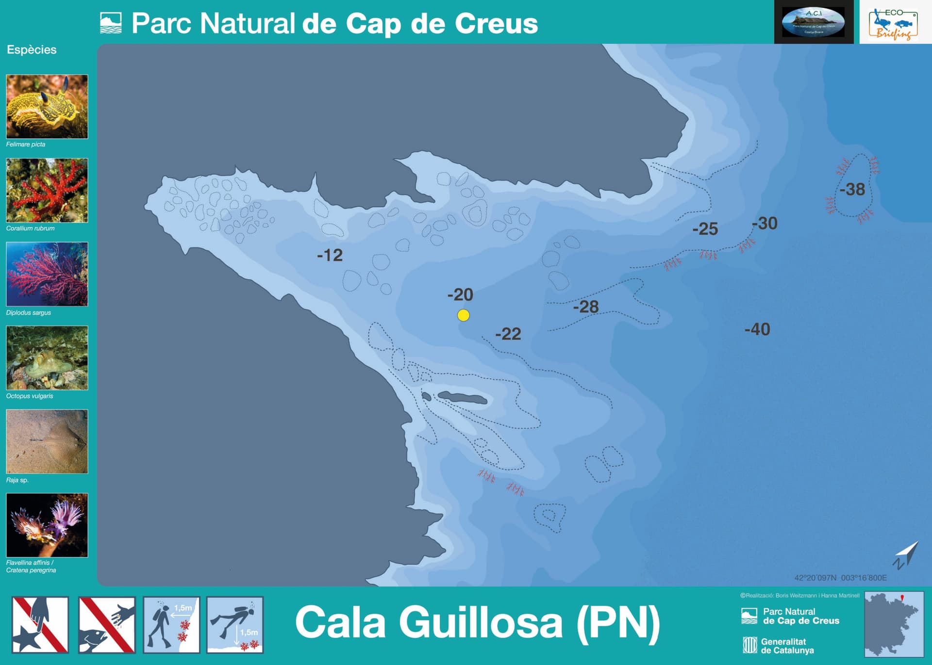
A rock wall carrying coralligenous growth drops through Cala Guillosa's working depth band, over a base that mixes bare rock with patches of sand. The wall rewards a slow, close look over a fast swim past it: scorpionfish sit motionless against ledges built up by the coralligenous growth, nudibranchs work the same crust close in, and conger and moray hold the crevices where rock gives way to sand at the base. Published figures for how deep the wall actually runs differ by source; agree a working maximum with whoever is briefing the dive before you descend. Boats tie off to park-managed mooring buoys, out of Llançà or Port de la Selva.
Cala Guillosa's own distinction is shelter: it sits on a stretch of the Mar d'Amunt that stays calmer than the more exposed points along this shore when the Tramuntana wind picks up, keeping a boat trip possible on days that shut down less protected sites. That shelter pairs with a wall built for patient macro work, not big-animal encounters: scorpionfish sitting still against the rock, nudibranchs on the coralligenous growth, moray and conger holding the crevices between the rock and the sandy patches at its base.
The published coordinates come from a single catalog entry, not a survey, so treat them as approximate. No season specific to this point is documented; the wider park reports its clearest water in April-May and September-October, and this site's own shelter makes it a reasonable fallback on days the Tramuntana closes more exposed points regardless of month. Do not confuse this dive with Cala Guillola, a similarly-named hiking cove by Cadaqués on the opposite, southern side of the park: that is a walking destination with no boat access and no connection to this site beyond the name.
What makes this dive site stand out.
Stays calmer than more exposed Mar d'Amunt points when the wind blows
Rock wall over a sandy base holds scorpionfish, nudibranchs, seabream, conger and moray eel
Boat-only, moored on park buoys, out of Llançà or Port de la Selva
42.3354°N, 3.2799°E
No season specific to this point is documented; the park's broader diving season reports its clearest water in April-May and September-October. Unlike more exposed points on this shore, the shelter here makes a Tramuntana closure less likely in any season.
The band a guided route and a separate catalog listing agree on stays within Advanced Open Water limits. The guided route's deeper figure calls for a Deep-diving certification or extension beyond that; the catalog listing's shallower reading never reaches it.
Summary
Rated for all levels on paper, but that covers only the shallow, guided portion of the site; working toward the deeper end of the published range needs Advanced Open Water at minimum, plus a deep-diving extension beyond that.
Safety considerations
What can go wrong here, and what divers do about it. Conditions change - take the briefing from the operator on the day.
Book a guided dive at this site.
PADI 5-Star center in El Port de la Selva with brand-new Aqualung gear, max 4 divers per guide, and year-round boat diving in Cap de Creus Natural Park.
SSI-affiliated dive centre in Llançà, the Cap de Creus Natural Park's northern access point, with air-only fills and a one-instructor-per-diver baptism dive.
PADI/CMAS/FFESSM centre in El Port de la Selva, running since 1994; daily boat dives across ~20 Cap de Creus sites including Massa d'Or, April-October.
Small PADI centre in Camping Sant Miquel, working Colera's Tramontana-sheltered coast into France's Cerbère-Banyuls reserve.
Get in touch to add or claim your dive center listing on DiveCodex.
Dive centres in Catalonia must require insurance from every diver on their dives, and must be able to offer a policy to anyone who has none.
One source's guided route works this point from 20 to 40 metres; a separate catalog listing gives 3 to 30 metres for the same site. Both agree on a 20-30 metre band, which stays within Advanced Open Water limits. Only the deeper figure, the 40-metre ceiling from the first source, pushes past what Advanced Open Water covers and calls for a deep-diving certification or extension. Set your planned maximum before the dive and confirm it with whichever centre is guiding you.
No. That description belongs to a different place, Cala Guillola, an unrelated hiking-access swimming cove by Cadaqués on the park's south side. Cala Guillosa is a boat-only dive site on the north shore, the Mar d'Amunt, reached from Llançà or Port de la Selva. The two names are easy to mix up online; check you have the dive site, not the walking cove, before you plan around either.
Log your dives - notes, photos, conditions and the marine life you saw - and share them as one public diver profile. What you share helps the next diver, too.
Log every detail
Depth, duration, conditions, gear, buddy, notes — all in one place. Import from Suunto and other dive computers.
Track marine life
Record species sightings on each dive. Build a personal catalogue of everything you've seen underwater.
Your public dive profile
Share your dive history, stats, and experiences with a profile page you control. Show the world where you've been.