

Diving Cap de Creus
German-run CMAS/RSTC dive centre on Cadaqués's Es Caials shore since 1975, with two shore dives near the door and boat trips on an informal daily schedule.
CMAS / other4 services2 languages
Also known as: Es Forcats E, Es Forcats E (RNP)
A cluster of rocky islets at Cala Jugadora's mouth in Cap de Creus, with two mooring buoys marking separate routes and a government-mapped six-species panel.
Last updated September 2026
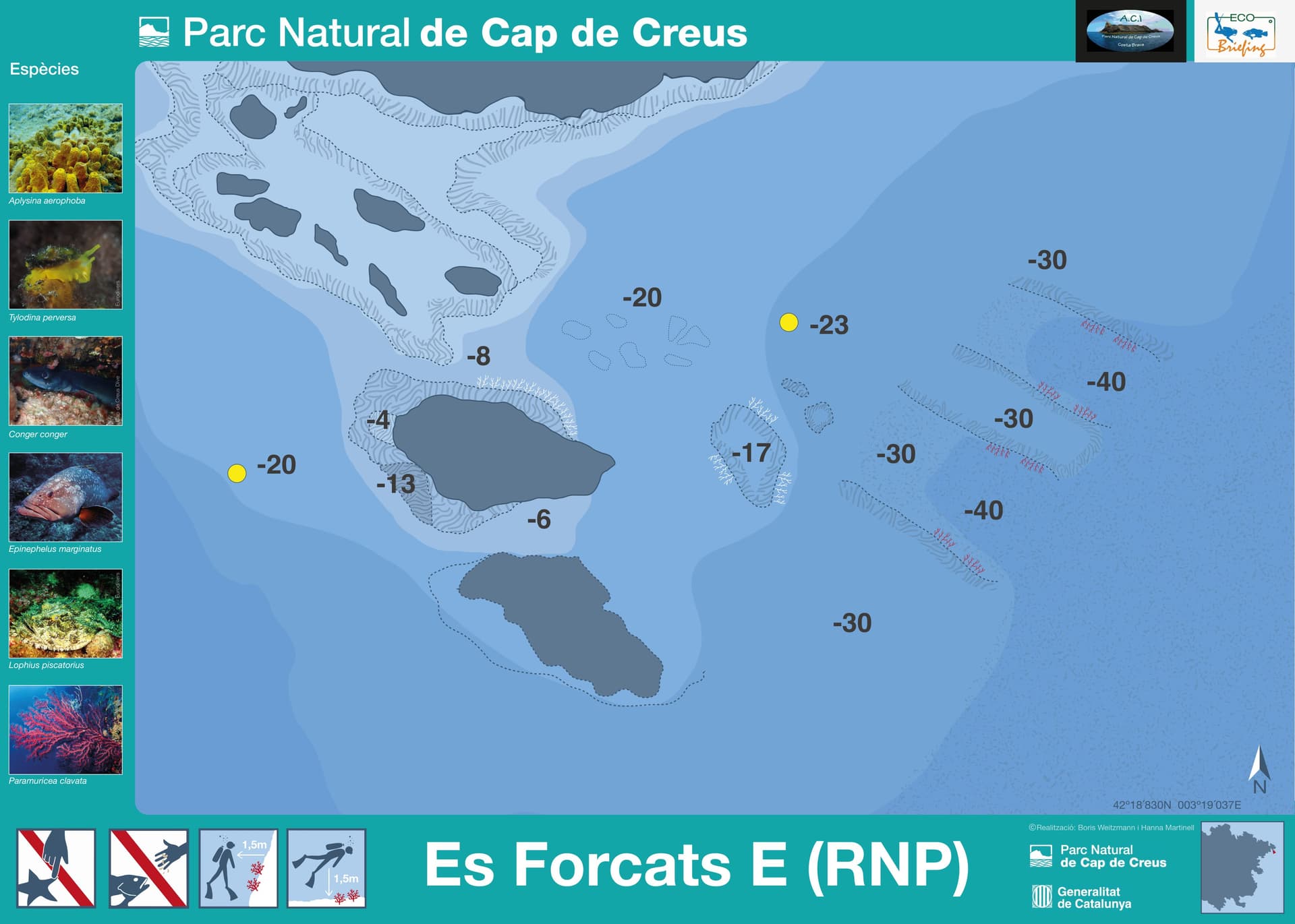
Several rock masses break the surface where Cala Jugadora opens onto open water, the outer islets in the eastern chain standing apart from the lower rock at the centre of the group. The park's own dive chart plots two separate mooring buoys here, one at 20 metres and one at 23, each anchoring a different route across the cluster, not two points on the same profile. From the shallower buoy, contour lines climb toward a rock mass cresting at 4 metres; from the deeper one, the ground keeps falling past 30 metres toward a mapped maximum of 40, on the outer, eastern side of the group. Paler gorgonian fans hold the shallower rock, and the red gorgonians that give the deeper chain its colour thicken as the wall nears its printed floor. The park's own eco-briefing sheet for this exact point names six species in total: dusky grouper, conger eel, monkfish and red gorgonian, alongside a yellow tube sponge and the nudibranch that grazes on it.
Es Forcats' own eco-briefing sheet singles out a detail most of the park's other itinerary points do not carry: a named predator-and-prey pairing, not a plain spread of reef regulars. The yellow tube sponge Aplysina aerophoba grows thick enough on this point's rock to support its own dedicated grazer, the nudibranch Tylodina perversa, a species that feeds on that sponge and nothing else; the sheet illustrates both together on the same panel. That specific relationship, more than a generic species checklist, is not the norm even among Cap de Creus's many numbered points.
This point sits inside one of the park's three Partial Nature Reserves, not its general zone: night diving between sunset and sunrise needs special authorisation here, and beginner "bautizo" dives are barred in the no-fishing sectors.1 Confirm current conditions and which of the two routes you will be diving with whoever is running your trip before you book, and keep a shallower backup plan in mind for the day.
What makes this dive site stand out.
Separate buoys at 20 m and 23 m plot different dives across the islet cluster
Sheet headlines a sponge and the nudibranch that feeds only on it
Fans thicken on the eastern islets between 30 and 40 metres
Several distinct rock masses break the surface at the cove's entrance
42.3138°N, 3.3173°E
Check with the centre running your dive for the season and conditions that suit this exact point.
AOW covers the mapped buoy positions at 20-23 m; Deep certification is needed for the park map's own 40 m maximum
The shallowest mapped mooring buoy already sits at 20 m, past Open Water limits
Book a guided dive at this site.
German-run CMAS/RSTC dive centre on Cadaqués's Es Caials shore since 1975, with two shore dives near the door and boat trips on an informal daily schedule.
SSI-listed dive centre inside the Carpe Diem Cadaqués complex, running since 2008 with three daily boat departures across 15 named Cap de Creus sites.

SSI Instructor Training Center in Cadaqués running guided dives to 25+ Cap de Creus Natural Park sites and a blue shark snorkeling program.
Get in touch to add or claim your dive center listing on DiveCodex.
Dive centres in Catalonia must require insurance from every diver on their dives, and must be able to offer a policy to anyone who has none.
The two figures most likely describe two different footprints. This point's own park sheet is a single survey with a printed maximum of 40 metres, matching the two mooring buoys it plots here, at 20 and 23. The operator's 50-metre figure covers Es Forcats together with two unnamed neighbouring sheets, Ses Orgues and Ses Ielles, a few hundred metres away, so it may describe that wider cluster instead of this exact spot. If the deeper number does hold here, it sits past the ceiling most training agencies set for Advanced Open Water and calls for a Deep rating. Ask your centre which of the three sheets they are actually diving before you settle on a number.
The park's underwater-itinerary sheet is titled 'Es Forcats E (RNP)', but neither dive centre on file uses an 'E' or 'East' qualifier, and independent grounded research confirms both simply call it 'Es Forcats'. The most likely explanation is that the 'E' marks an internal park itinerary or sector label: this same sheet plots two separate mooring-buoy positions, consistent with more than one route filed under one umbrella name, not a second, distinct place.
No single source treats them as one dive. A dive centre and a regional write-up group Es Forcats with its two neighbours, roughly half a kilometre to a kilometre away, under one descriptive line, but the park issues each of the three its own itinerary sheet with its own coordinate, and this page covers Es Forcats alone. Nothing here should be read across to the other two.
Log your dives - notes, photos, conditions and the marine life you saw - and share them as one public diver profile. What you share helps the next diver, too.
Log every detail
Depth, duration, conditions, gear, buddy, notes — all in one place. Import from Suunto and other dive computers.
Track marine life
Record species sightings on each dive. Build a personal catalogue of everything you've seen underwater.
Your public dive profile
Share your dive history, stats, and experiences with a profile page you control. Show the world where you've been.